
A veteran civil engineer is concerned about Barbados’ poor water drainage systems and how they affect the island during heavy rain, warning that inadequate drainage is contributing to road deterioration and increasing flood risks.
Andrew Hutchinson, a civil, structural and environmental engineer with more than 54 years of experience, shared insights from his work in stormwater management, watershed modelling, rainwater harvesting and major projects across Barbados, Antigua and Belize during a webinar on Stormwater Drainage Impacts on Urban Infrastructure on Friday.
Hutchinson argued that inadequate drainage is the primary cause of road deterioration across the island.
“The drainage on a scale of one to ten might make 2.5 or 3, but our drainage of our road system is actually very terrible. We seem to not recognise that drainage is the single greatest thing that will impact on the deterioration of roads.”
He explained that during road expansion projects in the 1980s, drains were often removed and replaced with kerbs and slipper drains rather than acquiring additional land to accommodate proper drainage infrastructure.
“With the curb and slipper, it meant that the road then became a drain, so once you got heavy rainfall, you can’t get the water off your road surface into storage ditches, your water stays on your road and runs to the lowest point until it jumps the curb and floods somebody’s land. So that’s where we are.”
The engineer maintained that the policy has had long-term consequences for road infrastructure.
“I still think it’s a faulty policy because nothing damages your road quicker than rainwater runoff. And then a close second to that is the Barbados Water Authority is already digging trenches and cutting the road to make connections without properly reinstating the roads.”
Pointing to the ABC Highway as an example of good drainage design, Hutchinson said the roadway incorporates stormwater ditches that allow runoff to be stored while gradually draining into wells.
“The ABC highway, unlike most other roads in Barbados, has proper stormwater ditches on the other side. And you can see here shortly after rain, the ditch is storing the water, it’s going to the well. And this is a good example of how it should be used because the well is there. You got a side entry with a grill to keep all the debris, but it has storage. That ditch could fill right up while your well is trying to take it.”
He also stressed the importance of proper hydrological analysis, particularly for larger watersheds, and recommended the use of modelling software such as HydroCAD.
“You need to do stormwater modelling using software programmes like HydroCAD and others. For a watershed that’s greater than ten hectares, using a 24-hour storm, every engineer has size and colour, needs to know how big it should be. Should I design for a ten-year storm, a 25-year storm? So you get precipitation rates.”
According to Hutchinson, one of the most important considerations in stormwater management is understanding the time of concentration — the period it takes water to travel through a watershed to a specific location.
“One of the most critical things in stormwater modelling is time of concentration. Time of concentration is, simply put, the time it takes for a particle of water to flow from the extremities of the watershed to the point of interest. So how long does it take the water to get from over there all the way to my culvert? That’s what I call a TC, time of concentration.”
As part of the solution, Hutchinson advocated for greater use of low-impact drainage systems, including GeoWeb surfaces and grassed parking areas, which increase infiltration and slow the movement of runoff.
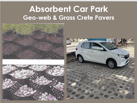
grass parking and geoweb.
“There are things we can do which are not done very often, but absorbent car parking….GeoWeb, you can get them four or six inches thick, different, and you can fill it with gravel, you can fill it with dirt, you can fill it with sand or mixture and it provides a very usable surface, you can even drive on it with trucks, and you can take reloads. But obviously, it facilitates drainage. Now, obviously, if you have GeoWeb done, it’s going to take longer for your water to flow across this to come out.”
He also recommended the use of check dams in gullies and underground storm chambers in urban areas to provide additional storage and infiltration where space is limited.
“Storage in rural or urban areas where your storm chambers are laid usually underground, so you can create your storage without having to create a ditch or a pond or holding channel….You can achieve a lot by using storm chambers…storm chambers are being used around Kensington Oval. Along Highway 5, there’s no room in the landscape against the highway to build a ditch or anything for storage, so it’s all underground. You cut a trench, you bury a storm chamber, you backfill it, and it provides storage and infiltration.”
During the question-and-answer session, Hutchinson called for wider use of ponds, detention areas, rainwater harvesting systems and small check dams across Barbados to reduce flooding, recharge aquifers and improve water security.
“I would say yes to all of the above,” he said when asked whether the island should pursue greater water storage.
“All of our flooding, our intense flooding due to storms in Holetown, Speightstown and Bridgetown can be mitigated by just simply going up in your watershed and building these little check dams.”
(LG)
The post Veteran engineer calls for drainage network overhaul appeared first on Barbados Today.